
|
|
A. GENERAL GEOLOGY, STRATIGRAPHY, AND HYDROLOGY
Following the Laramide revolution in which the southern Rocky Mountains were uplifted and the Cretaceous seas retreated, rivers flowing east and southeastward cut valleys into the pre-Ogallala surface. The deposition of the Ogallala Formation began in late Miocene to early Pliocene age and continued until late Pliocene time when the climate became more arid and up-warping of the High Plains area caused deposition to cease and erosion to begin. During Pliocene time, large quantities of eroded material from the Rocky Mountain region were transported by wind and water southeastward and deposited on the then existing surface of primarily Triassic and Permian age rocks. In certain areas, the depositional surface was composed of Cretaceous and Jurassic age sediments. The low valley areas were usually filled first by coarser materials such as gravels and coarse sand. As the valleys and basins filled, sediments overflowed to form coalescing aprons fed by braided streams that spread across a generally level plain. Eventually, the entire area was covered by Ogallala sediments until a maximum thickness of almost 900 feet (274 m) was attained in southwestern Ochiltree County (Muller and Price, 1979; Bell and Morrison, 1978). Throughout the time when the Ogallala sediments were being deposited, the Southern Rocky Mountains remained tectonically active, providing source material for the Ogallala Formation (Knowles and others 1984). The Ogallala Formation unconformably overlies Permian, Triassic, Jurassic, and Cretaceous strata and consists primarily of heterogeneous sequences of coarse-grained sand and gravel in the lower part grading upward into fine clay, silt, and sand. Gravel commonly occurs in layers in the basal section and ranges in size from boulders to pea size. In places, the Ogallala Formation contains some quartz gravel and caliche with pebbles and cobbles of quartz, quartzite, and chert being common. In the Northern High Plains the formation has been divided into three subdivisions: the Valentine, Ash Hollow, and Kimball, based on fossil vertebrates and flora. The subdivisions, often referred to as floral zones, are less distinguishable in the Southern High Plains. The sands are generally tan, yellow, or reddish brown, medium to coarse-grained, moderately to well sorted, unconsolidated quartz grains, interbedded with thin layers of clay and occasionally sandstone. The sand is generally poorly consolidated to unconsolidated, although local cementation by calcium carbonate and silica occurs. Grain size and condition of sorting is an indication of the high energy involved in the depositional process of these sediments. As expected, sand grain and gravel size decreases and sorting improves eastward. The gravel is usually associated with sand, silt, and clay and is occasionally cemented. Quartzite is generally the predominant rock type in the gravel, although a high percentage of limestone boulders and cobbles occur in the southern area along with weathered Cretaceous invertebrate fossils. The occurrence of limestone gravel and Cretaceous fossils indicate that a local source possibly contributed to the Ogallala sediments in the southern third of the area. Near the surface of much of the Texas High Plains are layers of resistant caliche known as "caprock". Caliche occurs in both Ogallala and post-Ogallala sediments and is formed by the leaching of carbonate and silica from surface soils and the re-deposition of the dissolved mineral layers below the surface. Although caliche layers occur primarily near the surface, deeper zones of caliche are also present. These deeper layers represent older soil horizons. The caliche ranges from crumbly to very hard and is almost impermeable although secondary porosity has been observed in many samples. Previously, the Ogallala was described as fluvial sediments deposited as a series of coalescing alluvial fans or plains with only minor amounts of eolian sediments (Seni, 1980). However, Reeves (1972), Hawley and others (1976), and Hawley (1984) recognize the Ogallala as predominately eolian sediments in parts of Texas and southeastern New Mexico. Outcrop and core studies by Gustavson and Winkler (1987) indicate the Ogallala in Texas and New Mexico consists of alluvial sediments that partly fill paleovalleys and widespread thick eolian sediments capping paleo-uplands and most fluvial sections. Calcic paleo-soils and fossil evidence suggest a depositional environment in a mostly semiarid to sub-humid climate (Winkler, 1990; Scholiast 1990; and Thomasson, 1990). Water-bearing areas of the Ogallala Formation are hydraulically connected except where the Canadian River has partially or totally eroded through the formation to separate the North and South Plains. Water-bearing units of Cretaceous and Jurassic ages combine to form the Rita Blanca aquifer in the western part of Dallam and Hartley counties (Christian, 1983). Lower Cretaceous units form two separate subcrops within the Texas High Plains, the Edwards-Trinity (High Plains) and the Edwards-Trinity (Plateau). Underlying these three aquifers and much of the Ogallala are Triassic (Dockum aquifer) and Permian formations. Thickness of the Ogallala Formation is primarily controlled by the morphology of the eroded pre-Ogallala surface. The greatest thickness occurs where sediments have filled previously eroded drainage channels. These channels generally trend east or southeast. Other areas of large Ogallala thickness occur in the northeast quadrant of the Texas High Plains where sediments have filled collapsed basins formed by dissolution of Permian evaporites. The saturated thickness of the Ogallala Formation ranges from a few feet to more than 525 feet (160 m). In general, the areas of greatest saturated thickness occur in the North Plains. In the South Plains, between Lubbock and Midland, the saturated zone varies from less than 50 feet (15 m) to 200 feet (61 m). Depth to water below the land surface can range from almost 400 feet (122 m) in parts of the North Plains to between 100 to 200 feet (30 to 61 m) throughout much of the South Plains. Ogallala groundwater is generally fresh, containing between 300 and 1,000 milligrams per liter (mg/l) of dissolved solids of which calcium, magnesium, and bicarbonate are the principal constituents. Some hydraulic continuity occurs between the Ogallala Formation and the underlying Cretaceous, Triassic, and Permian formations in many areas of the High Plains. For the purposes of this document, the Ogallala Aquifer will be considered to consist of the saturated sediments of the Ogallala Formation and any underlying, potable water-bearing units hydraulically connected with it. Post-Ogallala DepositionsPost-Ogallala sediments consist of windblown sand and silt, alluvium, and playa lake deposits. Windblown sands occupy the largest surface area of the High Plains of Texas and are of both Pleistocene and Recent (Holocene) age. They are primarily fine-grained to silty, sometimes calcareous, and are derived from lacustrine, fluvial, and eolian deposits. These sands and soils form sheet or cover sand, dunes, and dune ridges with thicknesses generally ranging from 0 to 10 feet (0 to 3 m). Alluvium is present as fluvial flood plain and terraced sediments along the more active streams and rivers. The deposits consist of poorly sorted, often cross-bedded, gravel sand, and silt. Lacustrine deposits, consisting primarily of clay and silt, line the bottom of the many playa lakes on the High Plains. The sediments are virtually impermeable, thus restricting natural recharge to the underlying formation. (Selected references are included in in the back of the Management Plan) B. CURRENT VOLUME IN STORAGE:Scope:In the counties of Dallam, Hartley, Hutchinson, and Moore the area of investigation was limited to that part of the counties that are within the defined Boundaries of the North Plains Groundwater Conservation District . Methodology:A Water Level Elevation Map was created using winter water level
measurements measured during the winter of 1996-97. The Water Level
Elevation map was superimposed upon a Historical Base of the Aquifer
Elevation Map (Red Bed) and data points calculated at the intersections of
the contours. In areas where these intersections were scarce, values were
interpolated from the nearest redbed and contour points. From these data
points a current Saturated Material Map was created. A value of saturated
material (to the nearest 10 foot interval) was assigned from the Saturated
Material Map at the center of each section, 3/4 -,½-, and 1/4 section of
land. That value of saturated material was multiplied by the appropriate
number of acres and a storage value of .15 and the resulting values were
then totaled. Corrections were made to account for any over estimation of
area calculations.
Total County Area-8472 mi sq; District Area-6495 mi sq with error correction-6485 mi sq Results:County Acre-feetDallam County Water in Storage: 9,748, 800 acre-feet not a recoverable volume Hartley County Water in Storage: 20,175,840 acre-feet not a recoverable volume Hansford County Water in Storage: 18,399,207 acre-feet not a recoverable volume Hutchinson County Water in Storage: 4,021920 acre-feet not a recoverable volume Lipscomb County Water in Storage: 19,140,480 acre-feet not a recoverable volume Moore County Water in Storage: 11,242,320 acre-feet not a recoverable volume Ochiltree County Water in Storage: 16,177,440 acre-feet not a recoverable volume Sherman County Water in Storage: 17,749,920 acre-feet not a recoverable volume Total 116,655,927 acre-feet not a recoverable volumeOmitting the bottom ten feet leaves a recoverable volume of 110,430,327 acre-feet Average Saturated Material 187.38 Ft C. ESTIMATED ANNUAL DECLINE (USAGE)Scope:In the counties of Dallam, Hartley, Hutchinson, and Moore the area of investigation was limited to that part of the county that is within the defined Boundaries of the North Plains Groundwater Conservation District . In the counties of Sherman, Hansford, Ochiltree, and Lipscomb the area of investigation includes the entire county. The area of investigation is estimated to be 6485 square miles while the counties in their entirety are 8472 square miles. The District includes 76.55 % of the area of the counties. Methodology:Water levels are measured annually between December and March in approximately 630 observation wells located throughout the District. A database with historical water-level measurements (630 observation wells) was used to calculate yearly (since 1981) average decline in the water-level of the Ogallala Aquifer throughout the District. From these, averages were calculated for 1982 thru 1986, 1987 thru 1992, and 1993 thru 1997. The third five-year average (1993 thru 1997) decline was selected to represent the present decline rate. Results:The Ogallala Aquifer within the boundaries of the North Plains Groundwater Conservation District is declining at an average of 1.74 feet per year (1,082,631 acre ft). |
|
|
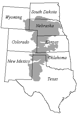 The
Ogallala Formation in Texas is the southernmost extension of the major
water-bearing unit underlying the physiographic province of North America.
It was named by Darton (1898) for the town of Ogallala, Nebraska, near the
type locality.
The
Ogallala Formation in Texas is the southernmost extension of the major
water-bearing unit underlying the physiographic province of North America.
It was named by Darton (1898) for the town of Ogallala, Nebraska, near the
type locality.