Ed
Wehling
Home PageCourses
Astronomy
Meteorology
Geology
Links
Astronomy
Meteorology
|
Quick Menu
Climate
Current Conditions (observations)
NWS Forecast Discussions--technical insider
forecast info
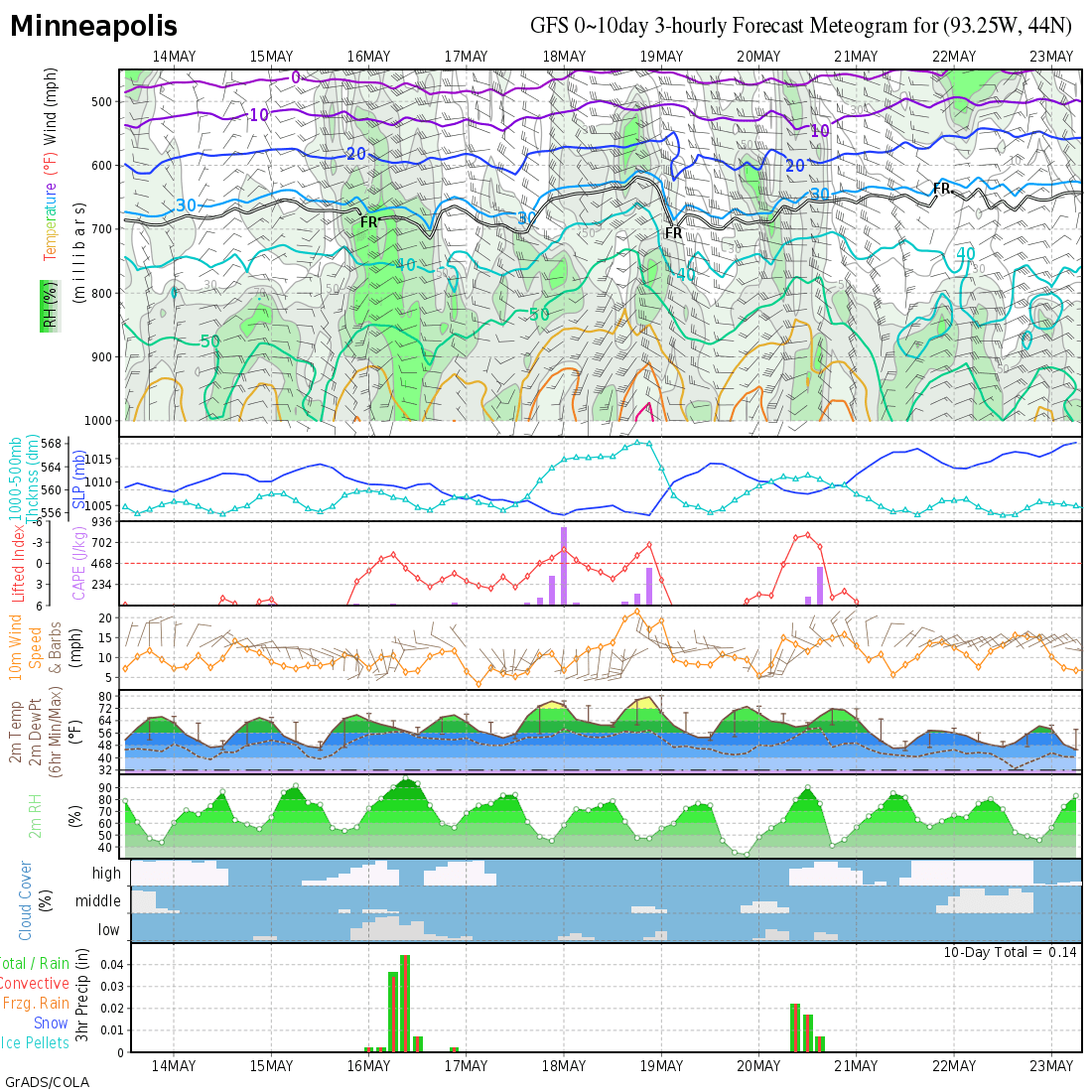
Forecasts
- National Weather Service Public
Coon Rapids
Zone
NWS zone forecast (official)
Point NWS forecast (with pictures)
alternate Twin Cities NWS forecast server
Cambridge
Zone NWS forecast (official)
Point NWS forecast (with pictures)
Minnesota
state
NWS
forecast
alternate NWS forecast server
National
Ohio State
- Fronts
--Hydrometeorological Prediction Center
--Tomorrow's fronts from
Intellicast
--24-hour front forecasts from
Wyoming
- Meteorological Development Laboratory
--Precip
and lightning forecasts for the next 3 hours
History
Hurricanes
Hydrology
Jet Stream
Lightning
NWS Numerical Model Output Forecasts
Past 24 hour
weather
Radar
Satellite Images
Severe Weather
Snow
Soundings
Surface Maps
- General map
Weather Channel
(fronts, highs & lows, radar)
Unisys (fronts, highs &
lows, satellite, radar)
Intellicast
Fronts
only--North America
Ohio State
- Contour maps (colored bands)
Unisys
(temperature, dewpoint, and many more)
Illlinois
(pressure with temp, dewpoint, wind dir, satellite)
- Good maps from
Ohio State
(streamlines,convergence, heat index, wind chill, and the usual)
- Weather channel menus
From Home page ,
mostly forecasts
From map
listings
- Station models
Minnesota
and West
Minnesota
and East
Upper Air Maps
- Mandatory heights
List from Unisys
List from
Wyoming
List from
Ohio State
- Contour maps (colored bands)
Unisys (500 mb,
prec water, LI,
and many more)
Weather Servers
If you want more information, maps, and so on, check out these sites.
Study help
Temporary
|